A part of Glasgow dominated by the M8 motorway is set for a redesign under plans for a new green public plaza and improved links between the city centre and West End.
Glasgow City Council has unveiled proposals to overhaul the area around Anderston railway station, creating new public space beneath the motorway alongside improved walking, cycling and wheeling routes.
The Connecting Anderston project would completely redesign the station forecourt with new paving, planting, rain gardens, seating, cycle parking and space for public art.
Landscaping would also be introduced to soften the concrete motorway setting and help manage surface water.
One of the most noticable changes would see the stepped pedestrian footbridge over North Street demolished.
The bridge, which the council says is little used and does not meet modern accessibility standards, would be replaced by upgraded street-level crossings.
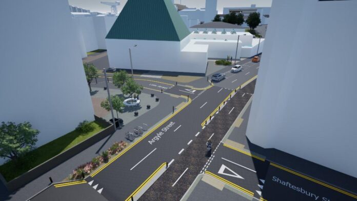
Step-free routes, tactile paving, new traffic lights, better lighting and clearer signs would also be installed.
The plans are designed to tackle the long-standing barrier created by the M8, North Street and the network of slip roads around Anderston Cross.
A new two-way protected cycle track would run to the east and west of Anderston station, linking the almost-completed Argyle Street Avenues route with existing cycle infrastructure on Elderslie Street.
It would create a continuous route between Glasgow city centre and the West End. Designers also plan to reference Anderston’s history as a centre of weaving through surface treatments and other details around the new plaza.
Councillor Angus Millar, Glasgow’s city convener for transport and climate, said: “Major roads and motorway infrastructure have long made the area around Anderston Station unpleasant and difficult to navigate.
“These proposals would create a safer, greener and more accessible public space at Anderston Cross and create a more pleasant link between Anderston and the newly improved Argyle Street West Avenue in the city centre.
“The plans would also close a key gap in the active travel network, creating a more joined-up pedestrian and cycle link from the city centre to the West End through the area around Anderston Station and beneath the M8 to help people get around the city more conveniently and safely.”
The scheme could also change the environment around nearby schools. Allan Lynn, headteacher of Anderston Primary School, said the school’s location beside the M8 and Clydeside Expressway meant pupils and staff were familiar with the effect busy roads can have on the area.
He said the proposals offered an opportunity to create a greener, safer and more welcoming space while improving connections to public transport and neighbouring parts of Glasgow.
The designs have now gone out to public consultation. Residents, businesses and people who travel through Anderston can comment until 22 November.
A public drop-in session will also take place at The Pyramid at Anderston on Wednesday 21 October between 3.30pm and 7pm.
Glasgow recently secured £9.3 million from the fund for a wider programme of walking and cycling projects across the city, including design work on Anderston Plaza.